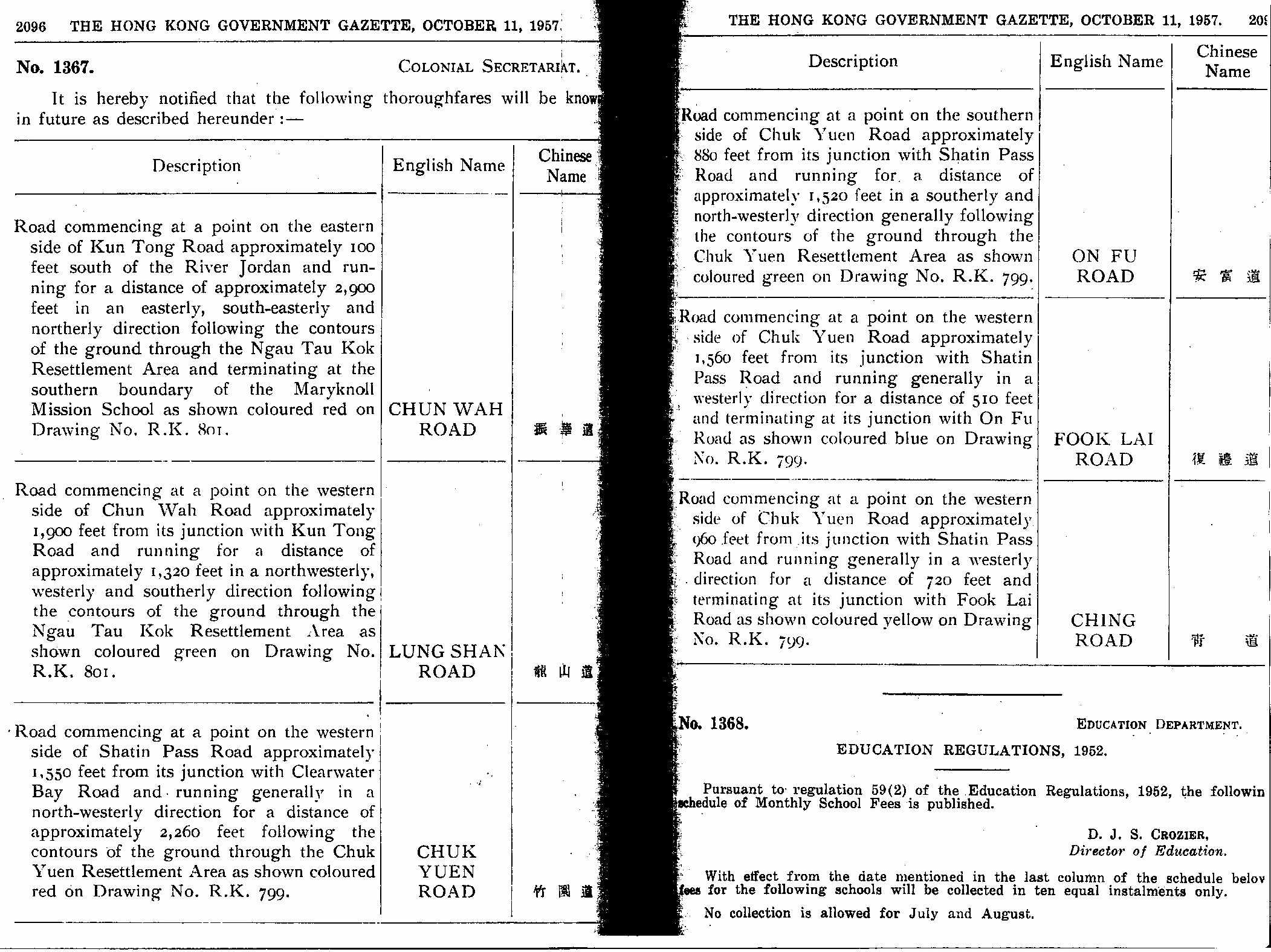
當天的憲示為香港幾個平房區內的道路命名。其中竹園有竹園道,復禮道,青道,安富道。想問問以上街道於合年消失?
另外,根據這憲示,振華道以前與一條叫 Kun Tong Road 的道路連接。
--Chun Wah Road
Road commencing at a point on the eastern side of Kun Tong Road approximately 100 feet south of the River Jordan and running for a distance of approximately 2900feet in an easterly, south-easterly and northerly direction following the contours of the ground through the Ngau Tau Kok Resettlement Area and terminating at the southern boundary of the Maryknoll Mission School as shown coloured green on Drawing No. RK 801.
[ 本帖最後由 azuma 於 2009-12-14 19:15 編輯 ] |
|
|
|
|
|
|
|
|
復禮道同安富道只係改0左名,佢地大慨係 82 - 83 年
竹園村重建之後,分別改名做穎竹街同彩竹街。  |
|
|
短 Trident 集團主席、愉景灣之友暨 sica何洛瑤 fans:Dbay116
|
|
|
|
|
|
Kun Tong Road 即係觀塘道
1967年12月8日改做kwun tong road
想問下樓主, 呢張圖係咪你自己scan的? |
|
|
|
|
|
|
|
|
原帖由 nwfb1601 於 14/12/2009 20:41 發表 
復禮道同安富道只係改0左名,佢地大慨係 82 - 83 年
竹園村重建之後,分別改名做穎竹街同彩竹街。 
大置上位置都係一樣?
咁52個站頭條係新加既架空段定點?
青道是埋沒於竹園北村裡?
同埋問,遠少少既獅子山上村,以前有冇車路到達? |
|
|
|
|
|
|
|
|
回復 4# 的帖子
|
將1981通用地圖同目前地圖比較,復禮道、安富道同穎竹街、彩竹街走綫大相逕庭...... |
|
|
FB/IG: KXEnviro | KX675
|
|
|
|
|
|
原帖由 kiwai 於 2009-12-14 20:58 發表 
Kun Tong Road 即係觀塘道
1967年12月8日改做kwun tong road
想問下樓主, 呢張圖係咪你自己scan的?
是的。 |
|
|
|
|
|
|
|
|
|
Advertisement
Advertisement
Advertisement
Advertisement
Advertisement
|